Death Valley National Park Map

Similar Products


Products of same category from the store


Product info
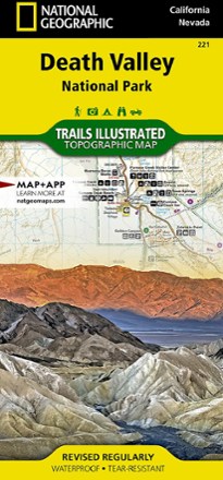
Despite its foreboding name and the fact that it is the hottest, lowest, and driest area in North America, Death Valley National Park maintains a great diversity of life in its dramatic terrain of salt-flats, canyons, mountains, valleys, sand dunes, and badlands. National Geographic's Trails Illustrated map of Death Valley National Park delivers unmatched detail and valuable information to assist you in your visit to this land of extremes. Expertly researched and created in partnership with local land management agencies, this map features key areas of interest including Badwater Basin, Furnace Creek, Scotty's Castle, Panamint Springs, and Stovepipe Wells.With miles of clearly marked trails that include mileages between intersections, this map will prove invaluable in your exploration of the park. A list of backcountry roads and trails complete with descriptions, lengths, and starting points will help you choose a route that's right for your activity level and recreation use. The map base includes contour lines and elevations for summits. Hot weather tips, a temperature chart, regulations, and safety suggestions are included as well. Every Trails Illustrated map is printed on Backcountry Tough waterproof, tear-resistant paper. A full UTM grid is printed on the map to aid with GPS navigation. More Information Product Code TI00000221 Folded Size 4.25 x 9.25 Flat Size 37.75 x 25.5 Scale 1:165,000 Copyright Date 2014 ISBN 9781566953214 UPC 749717009998 Weight Oz 3 Page Count 2
Price History
Price Archive shows prices from various stores, lets you see history and find the cheapest. There is no actual sale on the website. For all support, inquiry and suggestion messagescommunication@pricearchive.us